
Step 6: Environmental Planning Principles, Routing the Golf Course, Surveying, Site Preparation, and Clearing
Key Points
For new golf developments it is important for the design team to understand and apply environmental planning principles during the design process, including spatial principles, biological community principles, and water quality principles. The application of environmental planning principles will help to minimize the negative impacts of site disturbance and vegetative clearing and maximize the environmental benefits of the site.
Environmental planning principles can/should be considered by the golf course architect for the routing of the golf course and for the location and access to key infrastructure.
In line with these planning principles, once construction begins, site clearing should be done in a measured and deliberate way to ensure that nothing of potential value is removed from the site.
Consideration should also be given to how the debris from clearing can be repurposed elsewhere. This can save money and enhance the wildlife potential of the golf course.
* The first half of this article is excerpted and adapted from:Dodson, Ronald G. Sustainable Golf Courses: A Guide to Environmental Stewardship. Foreword by Arnold Palmer. Hoboken, NJ: John Wiley & Sons, 2005.
Allowing Site Biology to Dictate the Design
Designing a new golf course in consideration of existing, as well as potential, wildlife habitat will increase biodiversity more than a design that does not consider wildlife needs. The most basic elements that all wildlife need for life are space, food, shelter, and water. When the design team is intentional about preserving the areas of the site that naturally combine these elements, they allow the site biology to dictate the routing and design of the golf course, which will ensure greater harmony between the golf course and the land on which it is situated and ultimately maximize the environmental and economic value of the site.
Designing in Context with the Landscape
Minimizing disturbance is important because disturbance upsets ecological systems at the site, which negatively affects biodiversity, stability, and the overall ecological health of the site. Nutrient recycling is impeded or impaired and hydrological characteristics are altered. Nondisturbance is positive (both biologically and for cost savings) and should be a priority of the design and construction teams. Biological structure and function can best be maintained by prudent clearing and construction practices.
Protocols for clearing vegetation should be defined on a Clearing and Demolition Plan before construction begins. Areas should be identified for the following: stockpile areas for wood chips; stockpile areas for topsoil; areas where all vegetation between the marked limits will be removed; areas where only undesirable vegetation will be removed; location of service roads; limits of secondary and selective clearance; area for a transplant nursery; and limits of wooded zones, wetlands, buffers, and corridors.
The transplant nursery will be a place for short-term staging and maintenance of desirable native vegetation that is cleared from the site. The native plants in the transplant nursery should be appropriately potted and sustained until it is time to revegetate the property. The nursery needs to be in an area that has electricity and water, and that is convenient to revegetation locations.
Environmental Planning Principles
Situated on upwards of several hundred acres, a golf course site can encompass many complex ecosystems. By applying basic ecological concepts (broken into spatial, biological, and water quality principles), the design team will be able to design a golf course and supporting infrastructure that better protects the existing natural environment and supports biodiversity.
Spatial Principles and Guidelines
Large areas of habitat sustain more species than small areas.
If large areas of habitat cannot be created or preserved, many small patches of habitat in an area will help sustain regional diversity.
The shape of a habitat patch can sometimes be nearly as important as the size - interior habitat is better than the edges, so interior space should be maximized. Because the forest edge extends into the forest at least as far as the height of the trees, a forest habitat core must be at least twice as wide as the trees are tall before it starts to include any forest interior at all.
Edge conditions should be maintained, restored, or created – this is particularly important with clearing that is proposed within and adjacent to wooded areas. Construction activity (clearing as well as haul road activity) should be kept within the specified boundaries and follow the prescribed pattern of clearing. Regrading should be kept to an absolute minimum within these transitional areas. Where minor regrading is necessary, native topsoil should be reinstated. Native topsoil contains a seed bank that will encourage the development of a natural edge. Plantings along these edges should allow for the rapid establishment of appropriate native species.
Transition areas (ecotones) between habitat types are natural and support a variety of species from both specific habitat areas – ecotones should be allowed to develop naturally between adjacent habitat areas. Ecotones also help to isolate the wildlife core area from the impact of surrounding human activities, including chemical applications.
Fragmented habitats and ecosystems reduce diversity – even a narrow access road through a forest can be a barrier to the movement of small organisms, eliminate interior habitat, and introduce unwanted species.
Isolated patches of habitat sustain fewer species than closely associated patches.
Species diversity in patches of habitat connected by corridors is greater than that of disconnected patches – maintain or develop many corridors of similar vegetation to connect isolated patches of the same or similar community types. Wider corridors provide more wildlife benefits and protect water quality better than narrower ones.
Water bodies should be connected to the surrounding natural community by continuous corridors of natural vegetation for maximum wildlife value.
A mixture of habitat types sustains more species and is more likely to support rare species than a single habitat type (monostand).
Sustainable resource management requires native and naturalized plants – this practice accomplishes a variety of positive goals including (a) providing animals with the same food and cover plants they evolved with; (b) minimizing the need to supply extra water, fertilizer, cultivation, or other care; and (c) reducing or eliminating the need for pesticides because plants are coevolved with local pests. The first step to restoring a plant community is to eliminate the invasive exotic species. The second step is the introduction of the missing native plants, especially those with cones, berries, fruits, nectar, and nuts (that will more easily spread).
Biological Community Principles and Guidelines
Restoration of native plant communities helps to sustain diverse wildlife populations.
An increase in the structural diversity of vegetation increases species diversity – biological systems are composed of layers of vegetation, typically including big trees, small trees, shrubs, and herbaceous plants. Wildlife are largely dependent on a diverse structural habitat, so species diversity of almost all groups can be increased by adding vertical layers of vegetation to the plant community.
A high diversity of plant species ensures a year-round food supply for the greatest diversity of wildlife.
Retain dead, standing, and fallen trees, as they provide important nesting sites for many cavity-nesting species and a source of food for other species. Fallen vegetation provides shelter for ground dwellers. If it is impossible to provide sufficient cover naturally, artificial supplements can be added in the form of nest boxes or brush piles.
Species survival depends on maintaining minimum population levels – different species will have different minimum population requirements. The minimum population in a particular parcel will depend upon many factors.
Low-intensity land management sustains more species and costs less than high-intensity management – converting areas to native vegetation adapted to site conditions can reduce management intensity. Forest, grassland, and wetland communities are low-intensity landscapes.
All wildlife core areas should include access to permanent, shallow water. If a given area does not include a water body, access to one should be provided. This can frequently be accomplished through the creative routing of overland storm water (e.g. ditches or swales) or through the creation of corridors between core habitats and water bodies.
Water Quality Principles and Guidelines
Water quality protection begins with a regional watershed perspective – the watershed and water that it drains to are inseparably linked. Watershed management must focus on maximizing natural biogeochemical cycling and minimizing chemical and soil losses from the watershed.
Drainage from golf courses should not be discharged directly to water without adequate filtration – drainage should first be filtered through native plant materials or otherwise be cleaned through appropriate best management practices (for more information see Step 8: Storm Drainage Design and Installation and an Overview of SuDS).
The water quality of all water bodies (e.g. ponds, lakes, streams, etc.) should be protected by having a vegetative buffer around them – establishing low-management zones around water bodies will protect water quality. Highly managed turf to the edge of a water body should be avoided.
A high diversity of aquatic plant species ensures a year-round food supply for the greatest diversity of aquatic life.
An increase in the structural diversity of water body vegetation increases species diversity.
An increase in various habitats in deeper waters, as well as in the littoral areas, favors an increase in biodiversity of the water body – habitats may be created from such diverse items as old tires, used Christmas trees, and other material that will add three-dimensional structure to the water body.
A water quality monitoring program should be instituted for surface water, groundwater, and sediments – baseline quality should be established prior to construction, and criteria for management responses should be identified.
If available, appropriately treated reclaimed water should be used for irrigation of golf courses.
The Conservation and Enhancement Plan
With an understanding of basic Environmental Planning Principles as a foundation, the next step is to develop a specific conservation and enhancement plan for the property that is being developed. This process can take many forms, but it most commonly includes the following elements:
Assemble all available information for the project site, including topographic maps, soil maps, and aerial photography. Use this information to develop a geographic inventory of the major habitat types on the property.
On the ground, visit each area identified by the geographic inventory to determine what plant community is present in each location. Verification of major communities may be quite easy, while in-depth investigation of rare and specialized communities may require outside expertise.
Commission a wetlands delineation and also conduct a survey for species of special status under state or federal law. Both of these tasks are typically accomplished through the use of local consultants with specific expertise in these areas.
Conduct surveys of any key animal species that can be found on the existing site.
Combine all of this information to identify a series of wildlife core areas that should be preserved as the backbone of the green space network for the site.
For each core area identified, analyze the data to determine the size and shape of the area.
For each core area, prepare a list of management activities, including plant removals and additions, and habitat enhancements.
For each core area, determine edge and buffer zones. Block off areas to be protected during construction, and determine any other protective measures that may be required for each specific area.
Evaluate the entire property to determine how habitat core areas can be connected by corridors. Where existing habitat can be utilized for corridors, block it off for protection during construction. Where new corridors are needed, reconcile them with the other site plans and integrate them into the golf course routing and landscape design.
Develop habitat enhancement plans for all bodies of water on the property and make sure that they are connected by corridors to the site’s green space network.
Ensure that landscape plans for the site amenities, such as garden areas and landscaping along roadways and around buildings, are consistent with native and naturalized design guidelines, and that all naturalized areas are connected to the green space network of the site.
Review large-scale maps of the region, showing any existing green space networks, and consider how the internal habitat network of the property might be connected to them. Identify potential regional wildlife corridors and contact other property owners whose cooperation might be required to build a connected regional green space network.
Routing the Golf Course
Once the approximate boundaries of the site’s existing and proposed green space network have been determined, the golf course architect can route the golf course in consideration of existing, as well as potential, wildlife habitat. In addition to the green space network, a golf course architect will need to consider many other factors when routing the golf course, including but not limited to: minimizing earthmoving, utility access, golfer and non-golfer safety, viewsheds, etc… plus more intangible factors such as the rhythm and flow of the golf experience.
The routing plan will pinpoint locations for the proposed back tees, primary landing areas, and greens (also known as the primary reference points). During the design process, the golf course architect will likely prepare many routing plans before settling on a final one. The routing plan is a tool to conceptualize how the golf holes will relate to one another and also to the other existing and proposed elements of the development. Detailed design will be based upon the final routing.
Since vegetation can obscure smaller site features and may even make parts of the site inaccessible to the golf course architect during the detailed design phase, the final routing plan (and, to some extent, the detailed design) is actually more like the golf course architect’s best guess (within a reasonable margin of error) of the location of key features of the golf course and how much earthwork will be needed.
From Design to Site Preparation and Clearing
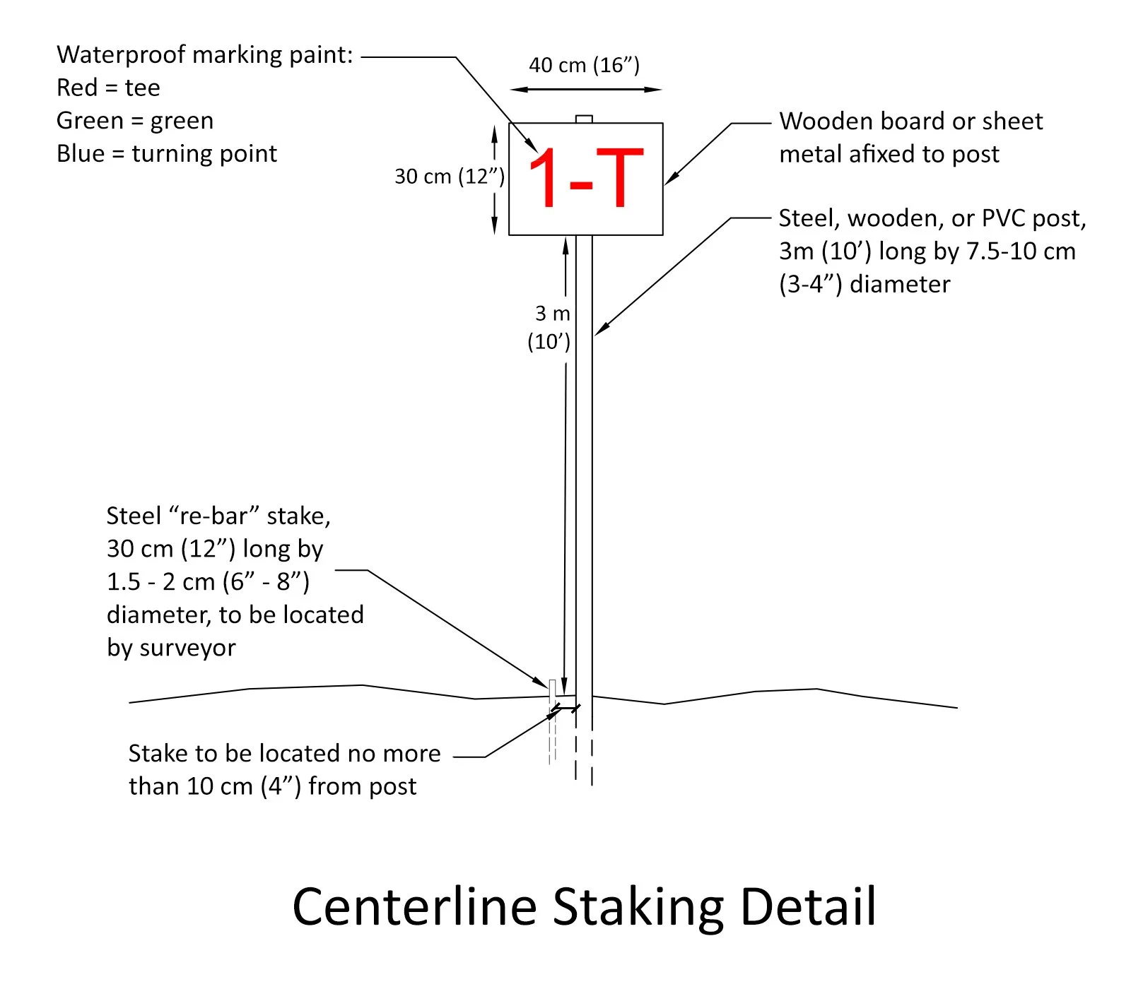
When the contractor begins working on the site, one of the first tasks will be to have the primary reference points from the final routing plan located and clearly identified by a surveyor. This is also known as centerline staking. These points will serve as reference points for much of the duration of the project so they should be easy to see from a few hundred yards away and relatively durable. Below is a detail showing a common method of designating primary reference points.
Additional Site Preparation Tasks, Phase 1 Clearing & Grubbing
Before widescale clearing can begin, the contractor’s surveyor must also mark the edges of disturbance, limits of environmentally sensitive areas or vegetation, and site boundaries. The contractor will install protective fencing in areas that will be prone to erosion and also to protect any outstanding vegetation or sensitive areas (including wildlife habitats) that are identified to remain. Once these limits are established, the contractor can perform “Phase 1” clearing and grubbing by removing all branches, brush, grass, roots, rocks, rubbish, shrubs, stumps, and other material that is unsuitable for a uniform playing surface from a swath along the centerlines of the holes, i.e. between the centerline stakes (detail with commonly used dimensions below). This will give the golf course architect a clear line of site so they can review the final routing plan between the primary reference points and begin to make small adjustments as necessary, based on previously unseen views, landforms, and vegetation.
Phase 2 Clearing & Grubbing
With the completion and approval of the “Phase 1” clearing and grubbing by the golf course architect, “Phase 2” clearing and grubbing can begin. This is the same process, but the clearing starts from where “Phase 1” ended and moves outward to within 10-meters (33 feet) of the limit of disturbance (detail below). During this phase of clearing and grubbing, specimen trees will be identified and protected (ideally with protective fencing beyond the dripline) while all other large trees will be cut down with their timber salvaged for sale or later use. The exposed topsoil should be carefully removed to a depth recommended by the consulting agronomist and stockpiled in an out-of-the-way location at this time.
The unwanted material that has been removed and that cannot be sold or salvaged during the first two phases of clearing and grubbing should be stockpiled and (if possible) reused. Otherwise, it should be disposed of away from the area of work so that it does not interfere with upcoming earthmoving operations, complicate drainage and irrigation installation, and potentially lead to future ground settlement and maintenance headaches.
Phase 3 Selective Clearing & Grubbing
Finally, the golf course architect will carefully inspect the area between the “Phase 2” clearing limit and the outer limit of disturbance to flag any vegetation that they want protected and saved, in a process also known as “Selective Clearing” (detail below). The purpose of this exercise is to preserve and highlight some vegetation (for an “irregular edge”) but also to clear away enough vegetation to allow for free movement of air and sunlight to encourage healthy turf on the edges of the golf holes. All undergrowth and debris should also be cleared from within this area to allow golfers to find and play errant shots.
A view down a golf hole centerline during Phase 2 clearing
Additional Opportunities for Sustainability
The golf course architect should take every opportunity to salvage, save, and reuse the material removed during clearing operations. Off-site transport for disposal should be the last resort. Some examples of what can be done with the material salvaged from clearing operations include:
Larger trees can be sold or used as fuel or building materials;
Smaller trees can be used as fuel or made into wood chips to be used elsewhere on the golf course or in the greater development;
Shrubs can be mulched to be used elsewhere in the greater development;
Debris can be buried in out-of-play and unmaintained areas (where settlement won’t matter) to create interesting landforms and reduce the need to import fill material;
Debris can be piled in out-of-play areas to create habitats for wildlife (as directed by a wildlife expert).
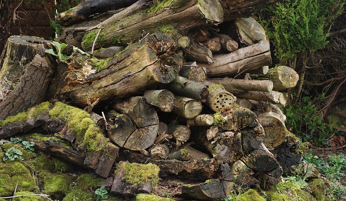
Woodpiles make for excellent wildlife habitats
Contact Sustain Golf for more information!
We firmly believe that common sense sustainable design, construction, and maintenance practices are the keys to the long-term outlook for the game of golf. We at Sustain Golf aspire to be on the leading edge of applying sustainability concepts to golf course design and construction.
We would be happy to answer any questions that you might have about sustainable golf course design, maintenance, and construction. Visit us at www.sustaingolf.com or contact us at the following email address for more information: matt@sustaingolf.com.
Up Next:
Step 7: Bulk Earthwork
References:
Hurdzen, Dr. Michael J. Golf Course Architecture: Design, Construction & Restoration. Chelsea, MI: Sleeping Bear Press, 1996.
Dodson, Ronald G. Sustainable Golf Courses: A Guide to Environmental Stewardship. Foreword by Arnold Palmer. Hoboken, NJ: John Wiley & Sons, 2005.
Photo Credit for centerline clearing: Ronald Fream
Peer Review:
Dr. Keith Duff, former UK government wildlife agency Chief Scientist, current Golf Environment Consultant